
Satellite-based AI products in Northern Plains convection
ProbSevere is a collection of nowcasting products for convective hazards. Two such products are LightningCast and IntenseStormNet, which are AI models that use solely satellite data to make predictions. LightningCast predicts the probability of lightning in the next 60 minutes, whereas IntenseStormNet detects the strongest portions of storms, which are likely to produce tornadoes, severe hail, and severe wind gusts. Both use data images from satellite instruments.
Last week, storms erupted on the South Dakota / North Dakota border within the warm sector of a surface low pressure system. The animation below shows the evolution of LightningCast (left) and IntenseStormNet (right) over time.
One important goal of LightningCast is provide actionable lead time to lightning initiation. Using GOES-16 GLM flash-extent density, we see that LightningCast provided about 30 minutes of lead time to the first flash in the southern cells, and then 25 minutes of lead time to the first flash in the later northern cell, when measured from the cyan 25% probability contour. As storms matured, we noticed how the probability contours were more packed to the west, the upstream side of the convection, whereas they were more diffuse in the downstream direction of convection (eastward). The diffuse nature of the eastward contours indicates less certainty on where lightning will be within the next hour, where the storm cores and associated anvil clouds were heading. We believe this is a signal that the LightningCast model learned the approximate motion of storms from a single timestamp of GOES-R ABI images. More research is underway using time sequences of images to see if that can improve implicit motion estimates and lightning predictions.
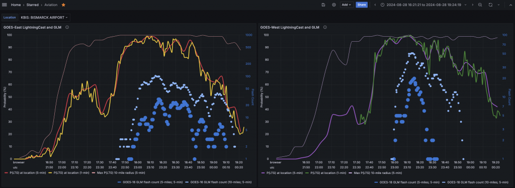
The northern cell in central North Dakota impacted Bismarck Airport. The lightning dashboard below shows how LightningCast probabilities from both GOES-East and GOES-West increased initially over the airport, then were fairly steady, and then rapidly increased over about 10-15 minutes before the first lightning strikes were detected within 5 miles of the airport by the both GOES-East and GOES-West GLM instruments. These dashboards, available to forecasters at airports, many stadiums, and over wildland fires, help to sync the LightningCast probability information and GLM-observed flashes with potentially vulnerable locations of interest, facilitating the National Weather Service’s decision support for key entities.
Looking again at the animation above, the IntenseStormNet uses images of 0.64-µm reflectance, 10.35-µm brightness temperature, and GLM flash-extent density to predict a probability of “intense” convection. The product really highlights the intense most regions, where strong overshooting tops and “cold-U” signatures reside, often colocated with robust “bubbly” texture from the visible reflectance. Notice the fact that many reported severe weather events werre associated with these features, created by the strong storm updrafts. Nearby pronounced anvil-edge gradients in the ABI channels and a core of GLM flash-extent density are also important features for contributing to higher probabilities.
IntenseStormNet output is a predictor in ProbSevere v3, machine-learning models that combine radar, satellite, lightning, and environmental data to predict the next-hour probability of severe hail, severe wind gusts, and tornadoes. IntenseStormNet can also be used as a stand-alone satellite-only severe-weather nowcasting tool in the absence of radar, such as in parts of the western U.S., in Canada, in oceanic regions, and in parts of Latin America.
LightningCast should be operational at NOAA/NESDIS in early 2025.
—————
Free Secure Email – Transcom Sigma
Transcom Hosting
Transcom Premium Domains