
Model estimates of information available from the GXS
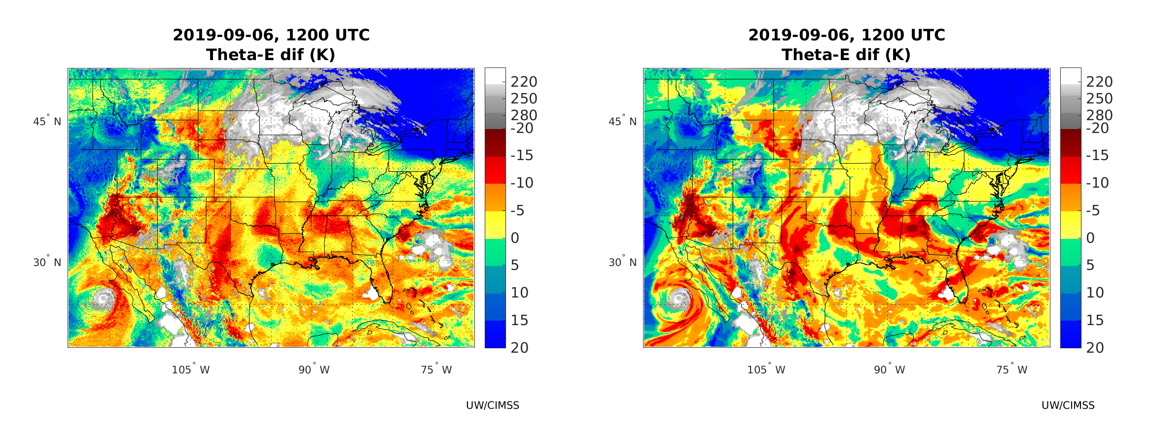
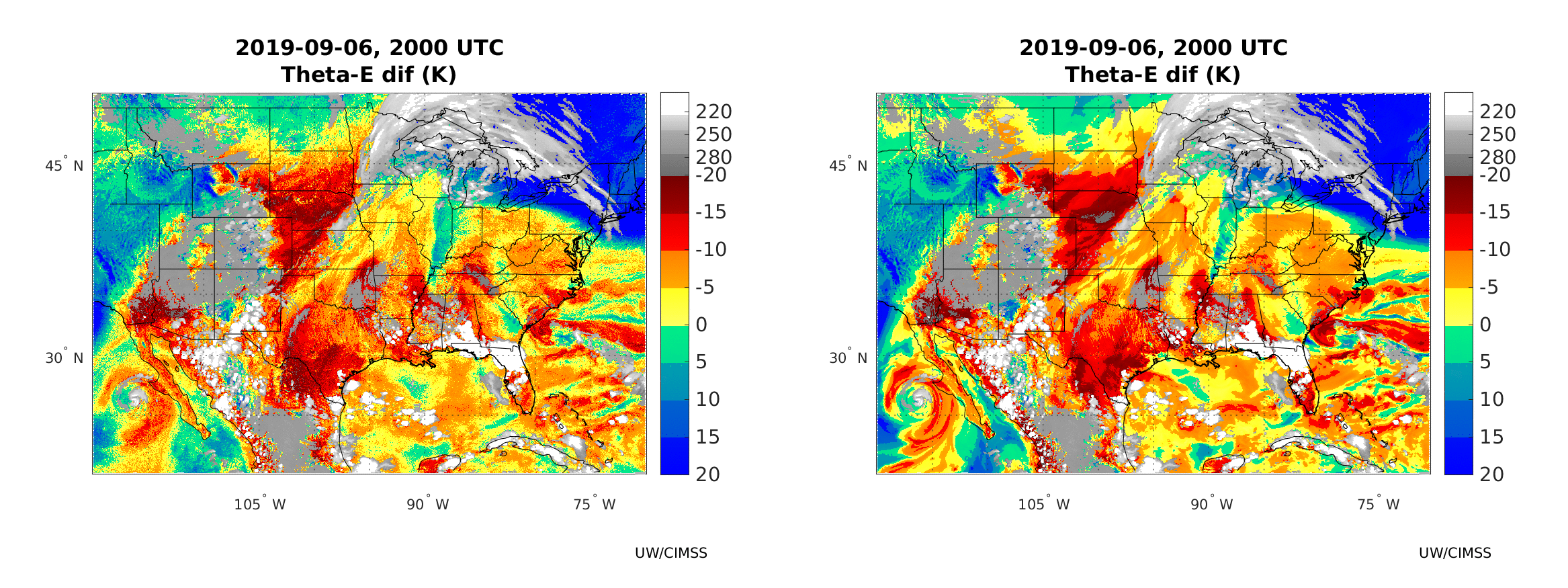
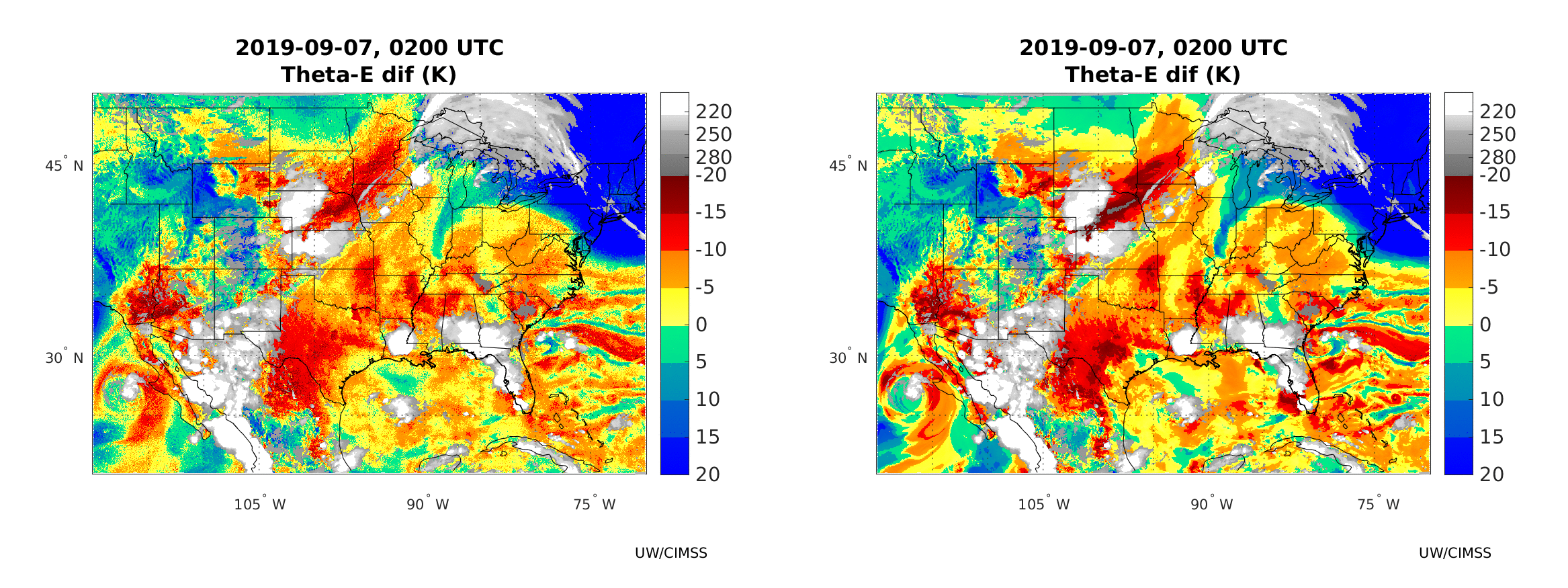
The GXS is the sounder that is proposed to be part of the GeoXO constellation of satellites that will launch starting in the 2030s as a replacement to the GOES-R satellites. (Note: GOES-U is now scheduled to launch no earlier than mid-May 2024). Beyond the GXS uses of radiance assimilation into global and regional models, there will be many applications associated with nowcasting. This post highlights one related to convection. What kind of capabilities will the GXS bring? That’s shown in the animation above. The left-hand imagery shows the thetae(500) – thetae(850) values computed from simulated sounder data: The extra fine spatial resolution (1-km) nature run (XNR1K) from the ECMWF model was averaged over the Sounder field of view (FOV), and a radiative transfer model was used to create Top of Atmosphere (TOA) radiances at all GXS sounder channels. Subsequently, temperature/moisture profiles were retrieved from these simulated sounder TOA observations using a deep neural network model. The retrievals are derived based on GXS radiances only (no NWP forecast used as first guess or background). Theta-e values at 850 hPa, 500 hPa were calculated from the retrieved T/Q profiles. The right-hand imagery shows thetae(500) – thetae(850) values calculated from the averaged XNR1K profiles (averaged to the Sounder field of view), which are used here as truth for validation.
There is remarkable similarity between the two fields, meaning the sounder data can give accurate estimates of potential instability, that is, thetae(500) – thetae(850). If thetae is decreasing strongly with height, atmospheric lift will lead to the rapid release of instability driven by strong latent heat release. In the animation above, strong convection develops near the strong negative values of thetae(500) – thetae(850) (red values); you can also see stable regions (in green/blue) near strong convection where cool downdrafts have stabilized the atmosphere. That’s also apparent in the shorter animations below: 2000 UTC on 6 September – 0000 UTC on 7 September and 0200 UTC – 0545 UTC on 7 September. The simulated GXS data here can alert a forecaster to where convection might (or might not) soon occur. There is a marked tendency for the convection to occur near gradients of potential instability.
—————
Free Secure Email – Transcom Sigma
Transcom Hosting
Transcom Premium Domains