
High Resolution Views of a Lake Michigan Winter
High spatial resolution satellites like the Landsat series operated by NASA and the US Geological Survey, or Sentinel operated by the European Space Agency, are often used for land process investigations. Their very high spatial resolution comes at the cost of less frequent overpasses over specific locations, and so they aren’t used as regularly for meteorological purposes as the coarser-but-more-frequent observations from low-earth orbiting instruments like VIIRS or the multiple observations per hour that geostationary satellites produce. However, phenomena of interest to meteorologists can still be found in these satellites if they happen to fly over at the right time.
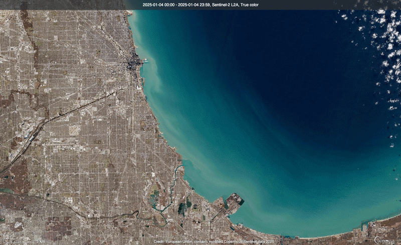
A month’s worth of observations from the Sentinel-2 satellite shows this very well. Depending on the channel, spatial resolution from Sentinel-2 can be as fine as 10 m which results in very highly detailed imagery of Earth’s surface and the clouds above it, but together the two Sentinel-2 satellites only pass over a location once every five days. Here, several images from the month of January 2025 are shown depicting Chicago and the southern tip of Lake Michigan. Early on in the month, the lake was ice-free as the water temperatures remained well above freezing. By mid-month, however, temperatures plunged into the single digits Fahrenheit overnight and ice began to form in the shallower regions near the lakeshore (for example, see this 15 January blog post).
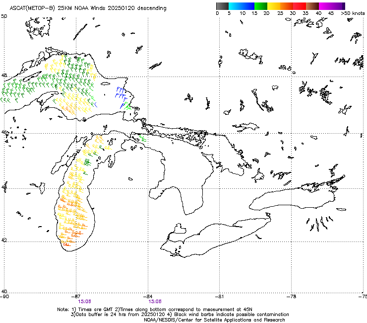
Consistent offshore winds helped push newly-formed ice into the middle of the lake. At times, these winds can be measured from space using the Advanced Scatterometer (ASCAT) instrument deployed aboard EUMETSAT’s Metop series of polar orbiting satellites which derives wind speed and direction from the radar reflective properties of surface water waves. The Great Lakes are large enough that useful wind measurements can be obtained from them via satellite. For example, ASCAT winds from 20 January show strong westerly flow from the land and over the lake.
As the wind pushed newly-formed ice away from the shore, new ice could form in the same shallow regions. The very low temperatures in mid-to-late January(the high temperature in Chicago was only 2 F on 21 January) caused a significant amount of western Lake Michigan to freeze.
The Sentinel overflights also uncovered some very interesting industrial impacts on cloud formation. The below image is from 24 January 2024. Very faint plumes are visible in the true-color imagery stretching to the northeast, originating from downtown Chicago and the steel mills and oil refineries of northwest Indiana. These plumes track across Lake Michigan where they serve as cloud nucleation that enhances the development of the elevated convection seen off of the western edge of the state of Michigan. In essence, the output of these significant areas of heavy industry is seeding clouds that form dozens of kilometers downwind. The very-small scale of these plumes means they are difficult to identify when using almost any other satellite system.

A zoomed-out view, showing the size and scope of these enhanced cloud regions, comes from the more coarsely-resolved Sentinel-3 Ocean and Land Color Instrument (OLCI). In this case, it appears there is additional seeding from industry in southwestern Wisconsin.

While these instruments that are focused on land studies won’t have applications for every day in operational meteorology, these examples show that they are still useful for gaining a larger-picture view of the environment and uncovering interesting processes occurring at scales that might be too small to otherwise be detected.
Imagery source: Copernicus Browser, https://browser.dataspace.copernicus.eu/
—————
Free Secure Email – Transcom Sigma
Transcom Hosting
Transcom Premium Domains