
Helene at sunrise and sunset on 26 September
GOES-16 Visible imagery (Band 2, 0.64 µm) from Mesoscale Sector 1, above, show the evolution of Helene for about 90 minutes shortly after sunrise on 26 September. Strong convection is wrapping around a center that occasionally has an eye-like characteristic. At the time of the animation, Helene was a very large (in area) Category 2 hurricane with maximum sustained winds of 100 mph. The visible imagery shows, along the western edge, anticyclonic cirrus outflow (and cyclonic low-level inflow) in addition to the compelling eye convection.
Helene is destined to interact with a mid-tropospheric system over the mid-Mississippi river valley that is shown below in the GOES-16 airmass RGB animation (the area of red/orange over western KY/TN).

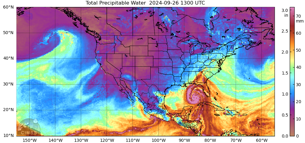
Helene is likely to produce prolific rains over the southeastern United States. MIMIC Total Precipitable Water fields for 1300 UTC on 26 September, above (from this site), suggest a stream of moisture moving north-northwestward from the Bahamas/tropical Atlantic into the southeastern United States. This in addition to the moisture moving northward with Helene itself will likely mean very heavy rains.
As sunset approached, Helene was in the northeast Gulf, nearing landfall, as a much more organized Category 4 storm. Visible imagery, below, shows convection surrounding a more prominent eye.
The GLM instrument observed lightning throughout the eye during this time of intensification, as shown below. Lightning within the eyewall is a trait of some hurricanes that are strengthening rapidly.
Helene poses significant risks to the southeastern US. Landfall is expected after sunset on 26 September, with a large storm surge and heavy rains. For the latest on Helene, visit the National Hurricane Center website, and also the National Weather Service Forecast Offices in Atlanta/Peachtree City, Tallahassee and Jacksonville.
—————
Free Secure Email – Transcom Sigma
Transcom Hosting
Transcom Premium Domains